Bitte benutzen Sie diese Kennung, um auf die Ressource zu verweisen:
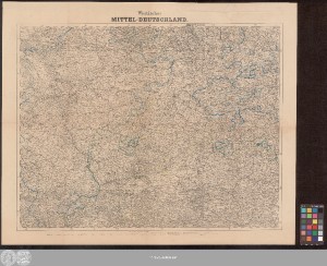
http://dx.doi.org/10.25673/64273| Titel: | Westliches Mittel-Deutschland |
| Weitere Titel: | Handtke's Karte von Mittel-Deutschland, westliches Blatt |
| Erschienen: | In Glogau : Druck u. Verlag v. C. Flemming, [circa 1850] |
| Maßstab: | 1:600 000 |
| Koordinaten: | E 6°06'-E 11°50'/N 52°30'-N 49°41' |
| Umfang: | 1 Karte; 53 x 69 cm Lithografie |
| Anmerkungen: | Nullmeridia: Ferro. - Maßstab in grafischer Form (Deutsche Meilen, Preussische Meilen, Badensche geometr. Stunden ...) Kopftitel Altkarte |
| Hinweis: | Koloriert |
| Sprache: | Deutsch |
| Schlagwörter: | Mitteldeutschland |
| Online-Ausgabe: | Halle (Saale) : Universitäts- und Landesbibliothek Sachsen-Anhalt, 2022 |
| Vorlage der Digitalisierung: | Universitäts- und Landesbibliothek Sachsen-Anhalt, Altkt D I 4 [5] 9 |
| URN: | urn:nbn:de:gbv:3:3-1192015415-309044537-16 |
| URI: | https://opendata.uni-halle.de//handle/1981185920/66224 http://dx.doi.org/10.25673/64273 |
| Open-Access: |  Open-Access-Publikation Open-Access-Publikation |
| Nutzungslizenz: |  Creative Commons Namensnennung 4.0 International") (CC BY 4.0) Creative Commons Namensnennung 4.0 International (CC BY 4.0) Creative Commons Namensnennung 4.0 International |
| Sponsor/Geldgeber: | Die Digitalisierung wurde durch die Deutsche Digitale Bibliothek im Rahmen des von der Beauftragten der Bundesregierung für Kultur und Medien (BKM) geförderten Programms NEUSTART KULTUR ermöglicht. |
| Enthalten in den Sammlungen: | Karten und Atlanten |
Ressourcen:
 |
|