Please use this identifier to cite or link to this item:
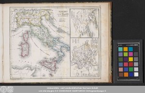
http://dx.doi.org/10.25673/101488| Title: | Italien als roem. Republik in ihrem vollen Bestande |
| Other Titles: | Plan von Rom Campania |
| Other: | Maximilian Frommann |
| Published: | Heidelberg : bei Karl Winter, [circa 1850] |
| Scale: | Unterschiedliche Maßstäbe |
| Extent: | 3 Karten auf 1 Blatt; 21 x 17 cm (links), 9 x 12 cm (rechts unten), 9 x 9 cm (rechts oben), auf Blatt 24 x 31 cm Lithografie |
| Annotations: | Bergstriche Erschienen in: Dittmar, Heinrich: Historischer Atlas. - Heidelberg : Winter, [circa 1850] ; Erste Abtheilung, Tafel VIb Karte |
| Language: | German |
| Online Edition: | Halle (Saale) : Universitäts- und Landesbibliothek Sachsen-Anhalt, 2023 |
| Original Publication: | Universitäts- und Landesbibliothek Sachsen-Anhalt, Altkt P II [1] 11 (4) |
| URN: | urn:nbn:de:gbv:3:3-1192015415-104571691X-13 |
| URI: | https://opendata.uni-halle.de//handle/1981185920/103446 http://dx.doi.org/10.25673/101488 |
| Open Access: |  Open access publication Open access publication |
| License: |  Creative Commons Attribution 4.0") (CC BY 4.0) Creative Commons Attribution 4.0 (CC BY 4.0) Creative Commons Attribution 4.0 |
| Appears in Collections: | Karten und Atlanten |
Ressources:
 |
|