Please use this identifier to cite or link to this item:
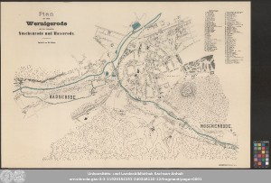
http://dx.doi.org/10.25673/119423| Title: | Plan der Stadt Wernigerode mit den Ortschaften Nöschenrode und Hasserode / bearbeitet von H. Gier |
| Publisher / Printer: | Schäfer, Th. |
| Published: | Hannover : autographischer Druck von Th. Schäfer, [circa 1890] |
| Scale: | circa 1:4 600 |
| Coordinates: | E 10°45'35"-E 10°48'40"/N 51°50'33"-N 51°49'15" |
| Extent: | 1 Karte; 59 x 91 cm, Blatt 67 x 100 cm Farblithografie |
| Annotations: | Ohne Kartennetz und Randgraduierung Titel oben links. - Erläuterungen oben rechts. - Drucker unten rechts Inselkarte Karte |
| Language: | German |
| Subjects: | Wernigerode Stadtplan |
| Online Edition: | Halle (Saale) : Universitäts- und Landesbibliothek Sachsen-Anhalt, 2025 |
| Original Publication: | Universitäts- und Landesbibliothek Sachsen-Anhalt, Altkt K II 3 [1] 5 |
| URN: | urn:nbn:de:gbv:3:3-11920154153-240248120-12 |
| URI: | https://opendata.uni-halle.de//handle/1981185920/121381 http://dx.doi.org/10.25673/119423 |
| Open Access: |  Open access publication Open access publication |
| License: |  Creative Commons Attribution 4.0") (CC BY 4.0) Creative Commons Attribution 4.0 (CC BY 4.0) Creative Commons Attribution 4.0 |
| Appears in Collections: | Karten und Atlanten |
Ressources:
 |
|