Please use this identifier to cite or link to this item:
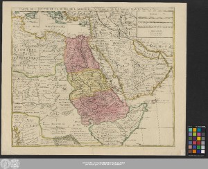
http://dx.doi.org/10.25673/39462| Title: | Carte De L'Egypte De La Nubie De L'Abissinie &c. / Par Guillaume de l'Isle de l'Accademie Royale des Sciences a Paris |
| Publisher / Printer: | Leth, Hendrik, de |
| Published: | A Amsterdam : Chez Henry De Leth, [circa 1730?] |
| Scale: | Circa 1:9 000 000 |
| Coordinates: | E 7°39'00"-E 60°15'00"/N 38°30'00"-S 1°00'00" |
| Extent: | 1 Karte; 47 x 58 cm Kupferstich |
| Annotations: | Maßstab in grafischer Form (Milles Communs de Turquie, Lieues Marines, Lieues Communes) Bergzeichnung Kopftitel. - Maßstabs- und Verlegerkartusche oben rechts Altkarte |
| Note: | Koloriert |
| Language: | French |
| Online Edition: | Halle (Saale) : Universitäts- und Landesbibliothek Sachsen-Anhalt, 2021 |
| Original Publication: | Universitäts- und Landesbibliothek Sachsen-Anhalt, Altkt B II 3 [15] 13 |
| URN: | urn:nbn:de:gbv:3:3-1192015415-1435566084-11 |
| URI: | https://opendata.uni-halle.de//handle/1981185920/41418 http://dx.doi.org/10.25673/39462 |
| Open Access: |  Open access publication Open access publication |
| License: |  Creative Commons Attribution 4.0") (CC BY 4.0) Creative Commons Attribution 4.0 (CC BY 4.0) Creative Commons Attribution 4.0 |
| Sponsor/Funder: | Die Digitalisierung wurde durch die Deutsche Digitale Bibliothek im Rahmen des von der Beauftragten der Bundesregierung für Kultur und Medien (BKM) geförderten Programms NEUSTART KULTUR ermöglicht. |
| Appears in Collections: | Karten und Atlanten |
Ressources:
 |
|