Please use this identifier to cite or link to this item:
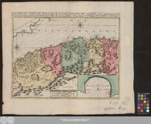
http://dx.doi.org/10.25673/39905| Title: | Nouvelle Carte Du Roiaume D'Alger, Divisée En Toutes Ses Provinces, Avec Une Partie Du Côtes D'Espagne &c. mis en lumiere selon les plus nouvelles et celebres Auteurs / par Reinier & Iosua Ottens à Amsterdam |
| Publisher / Printer: | R. & I. Ottens |
| Published: | [Amsterdam] : [R. & I. Ottens], [circa 1740] |
| Scale: | Circa 1:2 000 000 |
| Coordinates: | W 2°15'00"-E 8°45'00"/N 39°00'00"-N 32°00'00" |
| Extent: | 1 Karte; 40 x 53 cm Kupferstich |
| Annotations: | Kopftitel. - Maßstabskartusche unten Mitte Mit 1 Nebenkarte: "Baye D'Alger" Mit Bergzeichnung und Windrose Maßstab in grafischer Form (Lieues de France, Lieues communes d'Allemagne, Lieues communes d'Espagne) Altkarte |
| Note: | Koloriert |
| Language: | French |
| Online Edition: | Halle (Saale) : Universitäts- und Landesbibliothek Sachsen-Anhalt, 2021 |
| Original Publication: | Universitäts- und Landesbibliothek Sachsen-Anhalt, Altkt B II 3 [11] 13 |
| URN: | urn:nbn:de:gbv:3:3-1192015415-1435739574-17 |
| URI: | https://opendata.uni-halle.de//handle/1981185920/41860 http://dx.doi.org/10.25673/39905 |
| Open Access: |  Open access publication Open access publication |
| License: |  Creative Commons Attribution 4.0") (CC BY 4.0) Creative Commons Attribution 4.0 (CC BY 4.0) Creative Commons Attribution 4.0 |
| Sponsor/Funder: | Die Digitalisierung wurde durch die Deutsche Digitale Bibliothek im Rahmen des von der Beauftragten der Bundesregierung für Kultur und Medien (BKM) geförderten Programms NEUSTART KULTUR ermöglicht. |
| Appears in Collections: | Karten und Atlanten |
Ressources:
 |
|