Please use this identifier to cite or link to this item:
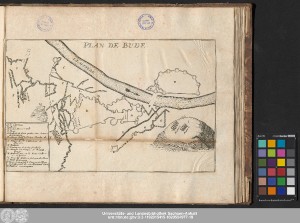
http://dx.doi.org/10.25673/56491| Title: | Plan de Bude |
| Publisher / Printer: | Amaulry, Thomas |
| Published: | [Lyon] : [Thomas Amaulry], [1687] |
| Scale: | Maßstab nicht angegeben |
| Coordinates: | E 19°02'00"/N 47°30'00" |
| Extent: | 1 Karte; 21 x 33 cm Kupferstich |
| Annotations: | Ohne Kartennetz Titel oben Mitte. - Legendenkartusche unten links Erschienen in: Histoire Du Siege De Bude. - A Lyon : Chez Thomas Amaulry, M. DC. LXXXVII Altkarte |
| Note: | Karte aufgeklebt und entlang des Randes beschnitten |
| Language: | French |
| Online Edition: | Halle (Saale) : Universitäts- und Landesbibliothek Sachsen-Anhalt, 2022 |
| Original Publication: | Universitäts- und Landesbibliothek Sachsen-Anhalt, Altkt V II [2] 36 (26) |
| URN: | urn:nbn:de:gbv:3:3-1192015415-1020594977-19 |
| URI: | https://opendata.uni-halle.de//handle/1981185920/58443 http://dx.doi.org/10.25673/56491 |
| Open Access: |  Open access publication Open access publication |
| License: |  Creative Commons Attribution 4.0") (CC BY 4.0) Creative Commons Attribution 4.0 (CC BY 4.0) Creative Commons Attribution 4.0 |
| Sponsor/Funder: | Die Digitalisierung wurde durch die Deutsche Digitale Bibliothek im Rahmen des von der Beauftragten der Bundesregierung für Kultur und Medien (BKM) geförderten Programms NEUSTART KULTUR ermöglicht. |
| Appears in Collections: | Karten und Atlanten |
Ressources:
 |
|