Please use this identifier to cite or link to this item:
http://dx.doi.org/10.25673/92108| Title: | Der Krieg gegen Rußland |
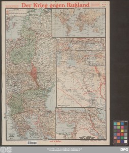
| Other Titles: | Der westliche Kriegsschauplatz Von der Ostsee bis zum Mittelmeer Weltkarte Zwischen Struma und Doiran-See Bei Monastir, Mazedonische Front Irakfront Englischer u. russischer Feldzug gegen das türkische Reich Zur grossen englisch-französischen Offensive Vogesen Am Isonzo Italien. Kriegsschauplatz In der Champagne |
| Part: | Nr. 18 |
| Publisher / Printer: | Verlag Paasche & Luz |
| Published: | In Stuttgart : Verlag und Ausführung der kartograph. Anstalt von Paasche & Luz, [1917?] |
| Scale: | unterschiedliche Maßstäbe |
| Edition: | Stand vom Mai 1917 |
| Extent: | 12 Karten auf 1 Blatt; 57 x 27 cm oder kleiner, Blatt 62 x 46 cm beidseitig, farbig Merktage, Kurze Kriegschronik zu Paasche's Frontenkarte (S. 81-88) |
| Annotations: | Mit Schummerung Randüberzeichnung Karte |
| Note: | Ohne Begleittext |
| Language: | German |
| Subjects: | Weltkrieg Ostfront Westfront Geschichte |
| Online Edition: | Halle (Saale) : Universitäts- und Landesbibliothek Sachsen-Anhalt, 2022 |
| Original Publication: | Universitäts- und Landesbibliothek Sachsen-Anhalt, Altkt C II 2 [3] 18 |
| URN: | urn:nbn:de:gbv:3:3-1192015415-492056390-10 |
| URI: | https://opendata.uni-halle.de//handle/1981185920/94060 http://dx.doi.org/10.25673/92108 |
| Open Access: |  Open access publication Open access publication |
| License: |  Creative Commons Attribution 4.0") (CC BY 4.0) Creative Commons Attribution 4.0 (CC BY 4.0) Creative Commons Attribution 4.0 |
| Appears in Collections: | Karten und Atlanten |
Ressources:
 |
|