Please use this identifier to cite or link to this item:
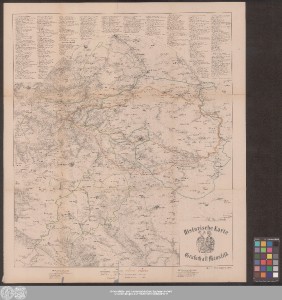
http://dx.doi.org/10.25673/39051| Title: | Historische Karte der Grafschaft Mansfeld / [Karl Krumhaar] |
| Publisher / Printer: | Schönerstedt, Wilhelm |
| Published: | Eisleben : Lithographie u. Druck v. W. Schönerstedt, [1872?] |
| Scale: | Circa 1:100 000 |
| Coordinates: | E 11°05'00"-E 11°51'30"/N 51°46'00"-N 51°15'30" |
| Extent: | 1 Karte; 56 x 53 cm Lithografie |
| Annotations: | Titelkartusche mit Wappen unten rechts. - Erklärungen über und unter dem Kartenfeld Bergstriche Ohne Kartennetz und Randgraduierung Karte |
| Note: | Koloriert |
| Language: | German |
| Subjects: | Grafschaft Mansfeld Geschichtskarte Luthers Elternhaus Provinz Sachsen Preußen Deutschland Geschichte |
| Online Edition: | Halle (Saale) : Universitäts- und Landesbibliothek Sachsen-Anhalt, 2021 |
| Original Publication: | Universitäts- und Landesbibliothek Sachsen-Anhalt, Altkt E III 4 [4] 2 |
| URN: | urn:nbn:de:gbv:3:3-1192015415-248083015-11 |
| URI: | https://opendata.uni-halle.de//handle/1981185920/39298 http://dx.doi.org/10.25673/39051 |
| Open Access: |  Open access publication Open access publication |
| License: |  Creative Commons Attribution 4.0") (CC BY 4.0) Creative Commons Attribution 4.0 (CC BY 4.0) Creative Commons Attribution 4.0 |
| Sponsor/Funder: | Die Digitalisierung wurde durch die Deutsche Digitale Bibliothek im Rahmen des von der Beauftragten der Bundesregierung für Kultur und Medien (BKM) geförderten Programms NEUSTART KULTUR ermöglicht. |
| Appears in Collections: | Karten und Atlanten |
Ressources:
 |
|