Please use this identifier to cite or link to this item:
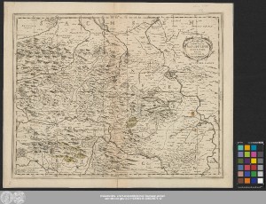
http://dx.doi.org/10.25673/39103| Title: | Comitatvs Mansfeldiæ Descriptio / Auctore Tilemanno Stella Sig. |
| Publisher / Printer: | Waesberghe, Joannes Janssonius, van Pitt, Moses Swart, Stephan Janssonio-Waesbergii |
| Other: | Nicolson, William |
| Published: | [Oxford] : Apud Janssonio-Waesbergios, Mosem Pitt et Staphanum Swart, [1681] |
| Scale: | Circa 1:160 000 |
| Coordinates: | E 9°55'-E 12°03'/N 51°49'-N 51°14' |
| Extent: | 1 Karte; 36 x 46 cm Kupferstich |
| Annotations: | Maßstab in grafischer Form (Miliaria Germanica) Titelkartusche oben rechts. - Verleger unten links. - Maßstab unten Mitte Mit Bergzeichnung Oben rechts: "XX" Erschienen in: Nicolson, William: The English atlas. - Oxford : Pitt, 1681 ; vol. 2 : Containing the description of part of the empire of Germany ... ; Karte XX Altkarte |
| Language: | Latin |
| Subjects: | Grafschaft Mansfeld |
| Online Edition: | Halle (Saale) : Universitäts- und Landesbibliothek Sachsen-Anhalt, 2021 |
| Original Publication: | Universitäts- und Landesbibliothek Sachsen-Anhalt, Altkt D II 7 [1] 3 |
| URN: | urn:nbn:de:gbv:3:3-1192015415-236520075-12 |
| URI: | https://opendata.uni-halle.de//handle/1981185920/39750 http://dx.doi.org/10.25673/39103 |
| Open Access: |  Open access publication Open access publication |
| License: |  Creative Commons Attribution 4.0") (CC BY 4.0) Creative Commons Attribution 4.0 (CC BY 4.0) Creative Commons Attribution 4.0 |
| Sponsor/Funder: | Die Digitalisierung wurde durch die Deutsche Digitale Bibliothek im Rahmen des von der Beauftragten der Bundesregierung für Kultur und Medien (BKM) geförderten Programms NEUSTART KULTUR ermöglicht. |
| Appears in Collections: | Karten und Atlanten |
Ressources:
 |
|