Please use this identifier to cite or link to this item:
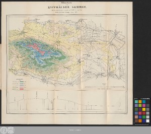
http://dx.doi.org/10.25673/39697| Title: | Höhen Karte vom Kyffhäuser Gebirge / nach den neuesten Messungen bearbeitet von C.R. Wolff Lieut. Ingen. Geogr. ; grav. W. Kliewer |
| Publisher / Printer: | Simon Schropp und Comp. in Berlin |
| Other: | Kliewer, Friedrich Wilhelm |
| Published: | Berlin : bei Simon Schropp u. Comp., 1855 |
| Scale: | 1:50 000 |
| Extent: | 1 Karte; 28 x 46 cm, auf Blatt 48 x 52 cm, gefaltet 19 x 12 cm Farblithografie |
| Annotations: | Mit 1 Profil Ohne Kartennetz Karte |
| Language: | German |
| Subjects: | Kyffhäuser |
| Online Edition: | Halle (Saale) : Universitäts- und Landesbibliothek Sachsen-Anhalt, 2021 |
| Original Publication: | Universitäts- und Landesbibliothek Sachsen-Anhalt, Altkt U I [3] 1/7 |
| URN: | urn:nbn:de:gbv:3:3-1192015415-40421276X-17 |
| URI: | https://opendata.uni-halle.de//handle/1981185920/41654 http://dx.doi.org/10.25673/39697 |
| Open Access: |  Open access publication Open access publication |
| License: |  Creative Commons Attribution 4.0") (CC BY 4.0) Creative Commons Attribution 4.0 (CC BY 4.0) Creative Commons Attribution 4.0 |
| Sponsor/Funder: | Die Digitalisierung wurde durch die Deutsche Digitale Bibliothek im Rahmen des von der Beauftragten der Bundesregierung für Kultur und Medien (BKM) geförderten Programms NEUSTART KULTUR ermöglicht. |
| Appears in Collections: | Karten und Atlanten |
Ressources:
 |
|